Uncharted has been awarded first place in a prestigious artificial intelligence (AI) competition co-sponsored by DARPA and the U.S. Geological Survey (USGS). Both agencies hope the results will help USGS extract intelligence from tens of thousands of historical maps that hold vital location data on critical mineral resources. Finding and mapping these resources in such a vast and varied landmass is a monumental task with significant implications for national defense and the impending clean energy transition. The competition aims to augment time-consuming human research in these areas with more efficient AI approaches that utilize machine learning and computer vision.
Through several generations of mineral exploration and mining, USGS has accumulated a tremendous amount of historical map data on the geological makeup of the country. Yet little of it is digitized or easily accessible. With a Congressional mandate to assess 50 critical minerals over 3.8 million mi2 of land in just a few years, USGS would face an arduous task if the data for these assessments had to be extracted manually from the USGS archives, map by map. That’s where the AI for Critical Mineral Assessment Competition comes in.
Leveraging state-of-the-art machine learning and computer vision capabilities, entrants were invited to develop automated techniques for collecting digitized, geolocated data from historical maps. The competition was split into two challenges. The first—Map Georeferencing—required entrants to geolocate arbitrary map images by detecting information such as coordinate systems or labeled place names. The second, still ongoing challenge—Map Feature Extraction—requires entrants to extract the location of features of interest present in the legend, such as points, fault lines, and polygons.
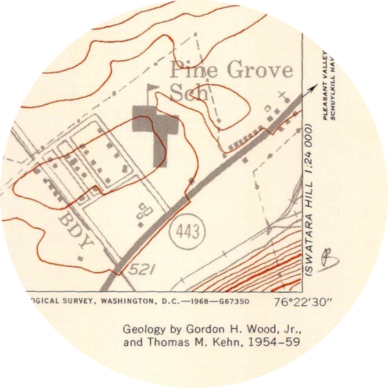
A sample of the many map formats found in the first set of challenge data: an unembellished map of superficial deposits (left), a topographic map with many colored layers and point features (center), and a topographic map incorporating human-made features (right). | Images: USGS
The USGS map collection spans back to the late 1800s. It encompasses a variety of forms—some hand-drawn, some computer-generated—that follow different conventions for orientation, symbology, labeling, projection, coordinate systems, and layered data. Any approach to automated extraction needs to handle all of these. And it’s not just the map contents that must be taken into account. The age of many of the source documents and the process of scanning them can cause visual imperfections that make clean extractions difficult, especially with overlapping map layers. At times, these challenges can resemble trying to get a computer to solve a Captcha, a task at which they are notoriously ill suited.
Given the difficulty of the problems, we were thrilled to learn that our approach to the Map Georeferencing challenge earned a first place finish. Our creative machine learning and computer vision based solution combines optical character recognition (OCR), entropy analysis, a tiered approach to extracting various coordinate formats or place names, and polynomial regression to build a geo-projection estimator for each map image. The estimator can then apply latitude and longitude coordinates to each pixel in the image, identifying its spatial context much more quickly than a human reader could. In the final challenge evaluation, this cascading approach to extracting location data helped us minimize error across the wide variety of USGS map formats.
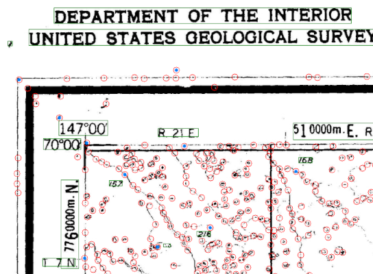
Our map georeferencing solution extracts various types of text (green boxes) as part of a cascading approach to automatically mapping pixels to geocoordinates for USGS maps. | Image: USGS, Uncharted
We’re hoping that the progress made on challenge one does in fact increase USGS ability to complete critical mineral assessments. In the meantime, we’re enjoying the hard work of coming up with a solution to the competition’s Map Feature Extraction challenge.
Learn More:
Acknowledgements
Uncharted’s entries in the DARPA AI for Critical Mineral Assessment Competition were designed and developed by Chris Bethune, David Giesbrecht, and Nathan Kronenfeld.
This post was written by Michael Crouch with editing and additional content by David Jonker.